The Waitangi Tribunal and the Porirua ki Manawatū Inquiry
The Waitangi Tribunal inquiry programme is designed to hear the range of claims (mostly historical) brought by Māori from particular areas in a single inquiry. There are 37 inquiry districts in total. In 2008, the Waitangi Tribunal received a number of requests to inquire into Treaty claims in the Taihape, Rangitīkei, Manawatū, Horowhenua and Kāpiti areas. The Te Hono ki Raukawa claims form part of the Waitangi Tribunal's Porirua ki Manawatū Inquiry. See inquiry documents on the Waitangi Tribunal site.
The Porirua ki Manawatū Inquiry is presided over by Deputy Chief Judge Caren Fox. The panel includes Monty Soutar, the Honourable Sir Douglas Kidd, Dr Grant Phillipson and Tania Simpson.
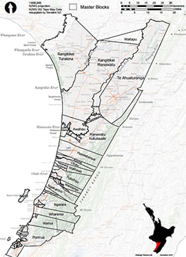
The western boundary of the Porirua ki Manawatū district extends to the Whangaehu River in the west and down the Kāpiti Coast to near the Porirua Harbour and includes Mana and Kāpiti Island. The southern boundary follows the boundary of the Whanganui-ā-Tara inquiry district from the Tasman Sea to the Tararua Ranges. The eastern boundary follows the boundary of the Wairarapa ki Tararua inquiry district from the Tararua Ranges to the Ruahine Ranges. The northern boundary follows the northern boundaries of the 1849 Rangitīkei-Turakina purchase, the 1866 Rangitīkei-Manawatū purchase, and the 1864 Te Ahuatūranga purchase, from the Ruahine Ranges to the Whangaehu River. Porirua ki Manawatū inquiry district map.
The Crown Forestry Rental Trust (CFRT) is supporting elements of the research programme.
The Porirua ki Manawatū Inquiry is presided over by Deputy Chief Judge Caren Fox. The panel includes Monty Soutar, the Honourable Sir Douglas Kidd, Dr Grant Phillipson and Tania Simpson.
The western boundary of the Porirua ki Manawatū district extends to the Whangaehu River in the west and down the Kāpiti Coast to near the Porirua Harbour and includes Mana and Kāpiti Island. The southern boundary follows the boundary of the Whanganui-ā-Tara inquiry district from the Tasman Sea to the Tararua Ranges. The eastern boundary follows the boundary of the Wairarapa ki Tararua inquiry district from the Tararua Ranges to the Ruahine Ranges. The northern boundary follows the northern boundaries of the 1849 Rangitīkei-Turakina purchase, the 1866 Rangitīkei-Manawatū purchase, and the 1864 Te Ahuatūranga purchase, from the Ruahine Ranges to the Whangaehu River. Porirua ki Manawatū inquiry district map.
The Crown Forestry Rental Trust (CFRT) is supporting elements of the research programme.
